Wednesday, September 7, 2011

Ottawa to Toronto the hard way...

Soon after the Coney Island vacation, it was back on the road.   Devora came down for annual her summer visit and giving her a ride back to Ottawa served the dual purpose of saving on the airfare, and giving Jackie and I the excuse to make a long over due visit to Toronto to visit old friends.

Sure you can go from Ottawa, Ontario to Toronto taking the Queensway to highway 416 to the 401 which would hold out the possibility of making the trip in 4 1/2 hours or less, if you were lucky and there were no volume related back ups at Peterboro or beyond, but otherwise, what's the point of seeing Canada at 70 mph, unless you had a good reason?  About the only thing Canadian you might see along the way are the Tim Horton's Donuts at the rest stops, a few Petro Canada gas stations, and some unlucky speeder being pulled over by an RCMP (mountie) officer.  Not a Canadian Tire store in sight.

You would see little else and have no sense of the rural beauty and British loyalist history of southern Ontario, built and inhabited by those with a different perspective on the American Revolution.    Highway 7, the mostly 2 lane, diagonal route between Ottawa and Toronto was the original Ontario segment of the trans-Canada highway (their Route 66) and is an education.  It travels through country settled by North American colonists who were not in favor of breaking with Britain, and  being no longer welcome in the soon to be USA,  made their way to various towns north of the border, many of which are along Highway 7  in the farms and townships of Lower Canada like Perth (still reminiscent of an old British barracks town), which we drove through, loved, and decided that it would merit a much longer stay next time around.   All seems to be forgiven at this point, and they welcomed us and our American money with open arms.  But maybe that forgiveness is not mutual.  I was recently rebuffed by a local store clerk in upstate New York who refused to accept a Canadian penny I mistakenly slipped her.  Maybe the revolution is not as over as I thought down here.


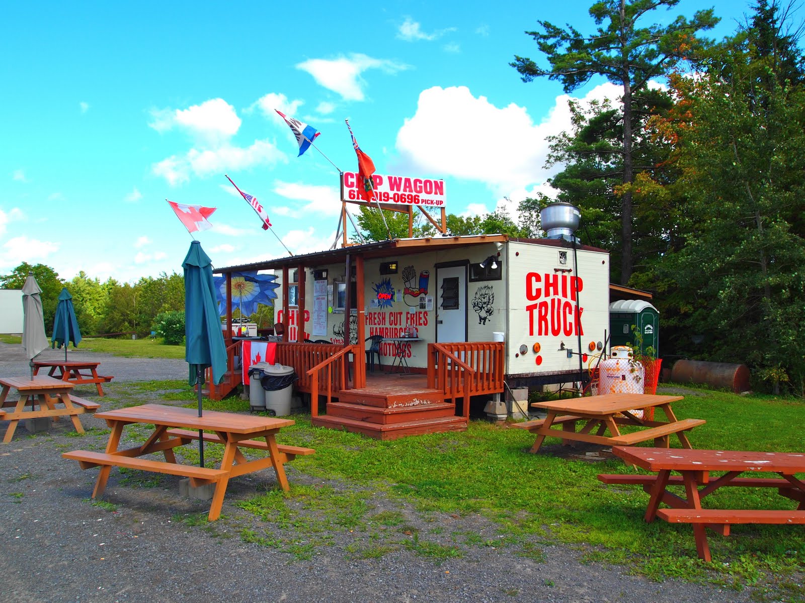
There was lots more to see along Route 7, and one day I will be reporting back, but there's only so much you can see and do when the trip is not really an amble and this time around, it was mainly the chip trucks and the roadside stands selling blueberries that caught my eye.


Jackie getting a large order of fries at the prototypical chip truck.  Of course I like mine with ketchup, Jackie has hers with mayo, tres belgique, and Canadians seem to like theirs with vinegar, very British.
And then there's the French Canadian contribution to North American culture, Poutine, a combination of soggy fries topped with cheese curds and drenched in a thick brown gravy.  But that's a culinary nightmare worthing of a posting all it's own.


Woody's Chips.   That thing on the roof is a box of fries, just to remind you who they are since they got rid of the truck and generally negated the whole reason for stopping there in the first place..  Maybe they really wanted a McDonald's franchise.


Had a long talk with Ken who retired from the highway department a few years ago and opened this truck, which he said was his true calling in life which he was now able to indulge.  He was very friendly, but we were still full and a bit queasy from the chips we had at that first truck not that long ago, so had to explain and apologize to Ken for not ordering some, but did promise to stop at his stand on our next go around.  He told us not to worry about it, but we do, and we will, but we will be taking a bit of a chance as well, because his was the last chip truck we saw on Highway 7, and if he's not there....


One of the many blueberry stand we kind of stopped at which became quickly photographically tedious, and therefore I won't bore you with them,  rounds out the sights we were able to see on the 7,  next stop, Toronto.

                                                                         Pablo


Friday, September 2, 2011

Even a hobo needs a holiday...

So every year around this time, if I haven't done it already, I like to drop down into that "hole in the ground", where ever it might be, and pay my 2 dollars or so for a subway ride down to Coney Island and Brighton Beach.  Its kind of an interesting prospect to head down into a subway station somewhere in Manhattan, hop on the N, Q, ,2, 3, or  some prosaically named train , and in a matter of 20 minutes or so, emerge into the daylight on the elevated line somewhere in Brooklyn to travel for another half hour or so to the end of the tracks, which happens to be Stillwell Avenue, Coney Island.  Where else but NYC can you head downtown and for two dollars, end up getting off on the subway platform at the end of the line and look out over the ocean.  New York/New York, so nice. they named it twice (no, I did not make that up.....wish I did).


There are many ways to start your journey to Coney Island.  This year, I was staying on Canal street, so I headed up Mercer Street to Prince...


Turned right on Prince Street and caught the downtown/ Brooklyn N train at the corner of Broadway and Prince...If you are in a hurry, don't take the N, it is a local that literally stopped at every station.


And down into that underground art gallery they call a subway station...


On to the N train, and 45 minutes later Stillwell Avenue/Coney Island.   Across from me was a guy in a bathing suit and tee shirt with a beach chair who was also in no particular hurry, and spent much of the trip on his cell phone talking  business, which seemed to be Wall Street related.  I normally would have moved to avoid him, but I was taken by the notion of being able to escape NYC, continue to do "big" business in in a bathing suit on the way to the beach, and not miss a beat.  Admittedly, I was jealous and intrigued by it all.  Pretty soon, we were at  the Coney Island stop and we all got out. 


And out onto the street...


You'll notice the empty lot across the street from the subway station.  That used to be part of a whole street of older buildings that housed skeeball, bumper cars, facination, a freak show, some cheap hotels/SROs,  and a variety of other things Coney Island, that have been torn down in the name of urban renewal, to join Steeplechase and the rest of Coney Island that used to be, leaving nothing but Nathan's, which I appreciate, but I wish they left more.  I figure that there is something political about it.  Maybe some politician with a soft spot in his heart for the annual hot dog eating contest.


Except for Nathan's,  the Wonder Wheel, and the skeletal remains of the parashute jump, of which there are countless photos you can refer to, there is nothing left of the Coney Island of the 50's I remember, which was only a remnant of what was there before.  Now there is nothing but the beach and the boardwalk, which was only sparely occupied on this warm August Sunday.

I walked along the boardwalk to Brighton Beach.  I took no pictures, because sadly, there is nothing left to see.  Only the sounds, Russian, Spanish, Brooklyn, arguments, laughter,  and the smells, grease, sweat, and garbage.  OK, I did take one photo, Paul's Daughter, because I took a picture of it last year with Paul's daughter's camera and her standing in front of it (which I don't have) , and because it will be torn down after this season to make way for whatever is part of the new improved plan for Coney Island.


Paul's Daughter, as the sign says, has been there since 1962, but soon to be no longer.  People often ask me if I have a picture of my daughter, but until recently, I didn't have anything current, but at long last, here is a picture of Paul's daughter.  As you can see, the fruit doesn't fall far from the tree.  Now, if I can only get her to take her camera a little more seriously.....


After a pleasant, but generally unremarkable walk down the boardwalk, it was over to Brighton Beach, where it started to drizzle, so it was up to the elevated line that runs above Surf Avenue, and back to Manhattan.


If this posting sounds a little wistful, or at least disgruntled, it is.  There is nothing left of the Coney Island of my mind but memories.

Next year, the hobo's summer vacation will be the A train to the Rockaways.  There is not much left there either, thanks to Mayor Lindsay who had 50 blocks worth of bungalows torn down leaving one large empty lot along the ocean that has been vacant for over 35 years.  But it too carries many memories of summers spent in the 1950's, and  its a nice ride.  I digress, but there is this certain photograph taken in the Rockaways in 1924 of my grandmother standing in front of a bungalow, holding my mother, who was about one at the time, and my grandmother was smiling.  It is the only time I remember seeing her smile.  But maybe that was the only period in her difficult life that she had something to smile about.

According to a number of recent NYT articles, there is a renaissance going on in the Rockaways right now which sounds quite positive and worthy of a look see.    I have great expectations, and my father who grew up there will be looking forward to my reports.  So next year, the A train.

                                                                           Pablo

Wednesday, August 31, 2011

Art Alley, Rapid City, South Dakota


As a somewhat jaded and road weary urban archaeologist with a particular interest in urban decay and guerrilla street art (although you would never know it from all of the entries until now), I thought I had seen it all until I stumbled on the most unusual thing, in the most improbable of places, Art alley, a riot of color, art, and anarchy in the center of downtown Rapid City, South Dakota, a sedate, orderly, thoroughly Presbyterian conservative small mid western city.  On one city block, behind the Alex Johnson Hotel between 6th and  7th street was a kaleidoscopic display of art, now predominantly graffiti, covering every imaginable surface and producing a mural testifying to the energy and vitality of this community no less important that the large projects commissioned by the WPA during the 1930's.  It cost nothing and required nothing more than the foresight and indulgence of the city officials who have allowed this post apocalyptic gallery/outpouring of energy to exist and evolve, while larger, supposedly "hipper" cities wage war on non-gallery approved artistic expression.

Just as you could never capture the grandeur of the Sistine Chapel in one photo, the following pictures are the best I could do to communicate the manic excitement of the alley.  It is only about 30 feet wide and the transit of the sun from one side to the other lasted only about 1 hour during which all of these pictures (and more) were taken on the Sunday morning before we were leaving town.


Hope you get the photo!!!  Given the ephemeral nature of street art and the politically driven whims of public officials, who knows if this will be there when you get there, and if it is, what it will look like.  It will certainly change and will be in need of redocumentation, so don't wait too long.  By the time you get there,  I'm sure everything here will be different.   As it should be. 

While in the alley, I was approached by a nicely dressed man a few years older than myself who was inquiring as to the camera I was using.  His name was Robert something (something Jewish) and it turned out that he was also from Long Island (what are the odds).  When I told his I was from Hewlett, he asked if I knew a certain person he served in the army with.  Of course, I said.  He lived across the street from my friend Phillip, and his mean, dreadful, sadistic, spinster aunt, was my 5th grade teacher who made my little ADHD life miserable for a year.  When I began to question him about what he was doing all the way out here in Rapid City, he became kind of vague, uncomfortable and seemed to unravel a bit, talking about some business opportunity or other, and at that point he said he had to go and get to church.  He sure didn't look like someone who would be going to church, but what do I know.

While in Rapid City I bought a pair of sneakers at the pretty great skate board shop where the kid there did not call me sir and treat me like some old guy.  In fact he seemed at least a little interested in my stories about being an east coast surfer when I was his age.  And then,  Jackie and I somehow bumbled into free movie night at the Elk theater across from the hotel and got to see the movie Lincoln Lawyer which we liked a lot.

So it was a pretty interesting and eventful 2 days in Rapid City.

                                                                     Pablo

Leaving Rushmore...

So we've left Mt. Rushmore and are ambling our way through the Black Hills of Dakota evocative both from the reference made in Rocky Raccoon and for the idea of black hills, whatever that might be.  Well, it turns out that the Black Hills are really green, evergreens mostly, and very reminiscent of the Adirondack Mountains in New York, where we come from, so if there's no pictures here, it's because I didn't take any.  Not that it wasn't ok, but it looked just like upstate New York or upstate almost anywhere, even New Mexico with it's national forests.  Its nice, but don't expect any surprises.  After this amble and some short stops in some very tacky,  not so interesting small towns that have sold  their souls to attract the Mount Rushmore tourist trade, it was getting a little late on Friday, and it became a mad dash for Rapid City, SD were we were spending a few nights.  As the old joke goes, for me anyway, the best view of the Black Mining Hills of Dakota was in the rear view mirror.


And back to the flat lands for which I seem to have developed quite an affinity.

                                                                     Pablo

Monday, August 15, 2011

North to South Dakota....The Badlands...


So, heading west out of Merriman for a short time on Route 20, we turned north on highway 73,  and soon found ourselves in South Dakota, and happy about it because we had never been in a Dakota, and we were on route to see the holy grail of all USA road trips, Mount Rushmore.   As an added bonus, we got to pass through the Bad Lands which we were looking forward to, but which did not seem all that bad viewed from an air conditioned car at 50 miles per hour, but as the movie and the printed information at the visitors center informed us, it was very, very bad, even horrible if you were making your way west in a wagon train at the rate of a mile or two a day, exposed to the heat, the cold, the bugs, the mind numbing tedium that drove many people crazy, the disease, the impassable trails, and if you lived through all that, the indians, who were not all that happy about your being there.  Having travelled extensively through some of the most inhospitable parts of the USA, it has always astounded me how these early pioneers did it.  Many, many didn't however and were buried along the way, so there must have been some sort of natural selection in which only the fittest and luckiest made it west.

Vaguely apropos to our disconnect with the landscape of the Badlands and all of the terror and misery it once held, was a vaguely poetic thought I had when I was having poetic thoughts.

Middle age, when life starts to seem
like a long series of wrong turns and
missed opportunities, New York to LA
at 65 miles per hour and coming up on the left,
the last chance to fill up for the next hundred miles.
Its now or never!#&@@!
As long as its more important to  be right than happy,
There can be no hope....


This was about as close as we got to anything remotely dangerous, and having spent a great deal of time in the barren expanses of the south west, the bad lands did not seem all that new or awe inspiring to us, but not uninteresting either for that matter.  I don't know, maybe I was expecting something badder, or maybe I should have gotten out of the car a little more at that point.  But I seemed fixated on the ghost towns of Nebraska at that point, and I had already done my southwest thing (refer to the blog entry "Seeing")  so it was hard to get enthusiastic.   But in case you were curious, here you go.


So after our visit to the badlands, we were off to Mount Rushmore, which it turned out was quite an inspiring sight.  In spite of the millions of times you've seen it in photos a, movies, and postcards, it was kind of breath taking to be there.  I was quite surprised by my reaction!!!  I guess I'm not as jaded as I thought.


In preparation for our pilgrimage to Mount Rushmore, we watched North by Northwest which was shot there in the late 50's or early 60's.  Much to our disappointment, the evocative visitors center/restaurant in the movie was gone and replaced by some oversized, overwrought, stone extravaganza with promenade, 50 state flags and an overkill that would have made the Disney people proud.  Luckily, when viewing the mount, it was to your back and easily forgotten.

But all in all, the reviews here are 4 thumbs up.  Glad we did it.  Onto Rapid City, SD to spend Saturday and Sunday morning.

                                                                    Pablo

Wednesday, August 10, 2011

Merriman, Nebraska


Our last stop on route 20 along the northern edge of the sand hills in Nebraska, before heading north into South Dakota, was Merriman, another town that was more or less devoid of life and activity, the first time we visited in May 2011.  With the exception of the town maintenance man, a customer at the bank, and the teller who came out to see what we were up to, and was kind of excited to hear that we came all the way from New York, those were the only people we saw.  On this visit, there was a little more activity, as noted below.


The grain elevators and railroad line that passes by seem to indicate that while there are only about  118 people listed as the present population the grain depot was and continues to of great importance to this town.  But regarding the town itself, other than the bank, a post office, and an auto mechanic's shop, there was no other active business establishment  along the main street of what appears to have once been was a busy center of commerce running perpendicular to the tracks and depot.  The grain elevators are in good condition and seem to indicate that this continues to be an active service of Merriman.

Even the bar was a little outside of town along Route 20.  Appropriately named the Sand Bar.  No beach, but lots of sand.


These are most of the buildings along the sunny side of the main street.  They provide a good sampling of what is there to see.


The old fire house that is now the the headquarters of the town maintanance department that is part of the only three contiguous buildings in this once thriving town.


.


The bank, and next to the bank is a placard displaying the many cattle brands of the ranches of the sand hills.


While in town, which seemed quite busy at that time of the day, I got talking to this rancher, Robert Moreland, who has lived and worked there his whole life and told me he has written a number of books and asked me to get in touch with him when I got back, and I will.


An old storefront at the intersection of route 20.


The Merriman Dance Hall.  Close to 100 years old, it was the old theatre, meeting hall, and general center for entertainment.  The stage is still there, but little else.


I am usually obliged to take a picture of the post office, but in this case it nothing but a double wide on the shady side of the street and not much to see.


Soon after leaving Merriman, we made a right turn onto the 73 heading into South Dakota and our tourist's homage to Mount Rushmore.

                                                                           Pablo